Showing posts with label Social Media. Show all posts

Wednesday, February 9, 2011

Spatializing Photogenic Density - Assignment 3 Final


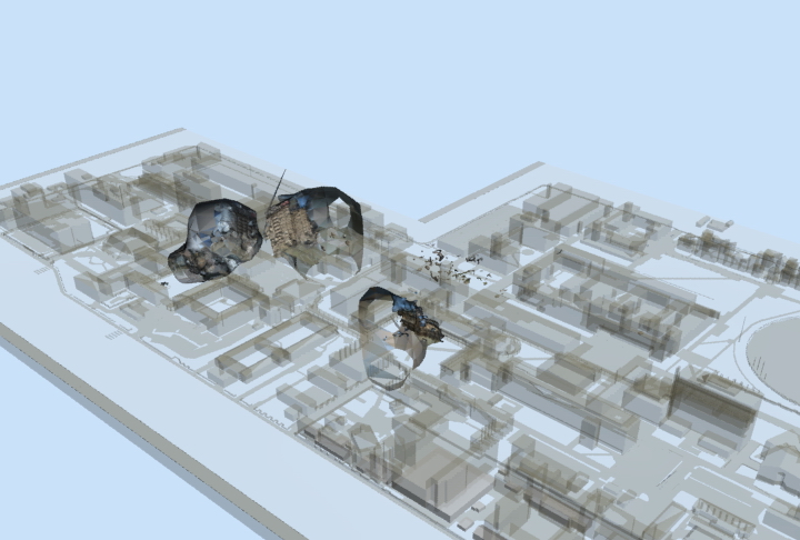
This video shows the outcomes of a series of experiments involving Social Media, Yahoo! Pipes, and Photosynth. This explores the possibilities of creating new spaces and 3d objects through photogenic density, turning point clouds from Photosynth into useful information for design decisions, something which at the end i called a "photogenic viewing platform".  

All the photosynth point clouds were left as-is and no alterations were done to them. Rather than trying to make precise reconstructions, this experiment favoured the uncontrolled and unintentional in what makes up social media.

Setbacks during this experiment included problems with the Yahoo! Pipe. Ultimately a mixture of Pipes and direct rss feeds were instigating, weakening the "mashiness" of the Pipe.


Monday, May 31, 2010

Submission 02 Documentation


Update on The Research Matrix


Still 01 - Synopsis of Methodology


Still 02 - Experiment 01: Information (Collective) - Click (HERE) to be forwarded to the full resolution version stored in Deviantart. 


Still  03 - Experiment 02: Information (Negotiated/Discursive) - Click (HERE) to be forwarded to the full resolution version stored in Deviantart. 

Experiment 02 - Information(Negotiated/Discursive).

Check out below video and stills for the main results of my experiment (in response to the questions raised in my previous post) concerning aggregated read-write representation of places as seen through social media. Main documentation of these images and experiments will be presented in the next post.


Brief Overview: - This experiment explores the virtual representation of geographic places by feeding a mash-up of Social Media API feeds into a Geographic Information System via Yahoo Pipes. Density maps are created based on the rating that each entry (point) received from its peers. This experiment led to the identification of "Viral Places";- features that are not physically/visibly centered but have achieved the same popularity in density in terms of its representation in social media environments.


Tuesday, April 13, 2010

Urban Tapestries. Social Tapestries: Public Authoring in the Wireless City

Found a social media, geo-tagging experiment that has been done in the past involving mobile technology. Unfortunately, the project is beyond its active stage, all program source codes, live-feeds etc, are all gone.


"Urban Tapestries is an interactive, location-based wireless application allowing users to access and author location-specific multimedia content. It is a forum for sharing experience and knowledge, for leaving ephemeral races of peoples' presence in the geography of the city...Users will be able to add new locations, location content and the 'threads' which link individual locations to local contexts. Urban Tapestries privileges the experience of the user over typical 'publishing' systems which control and author the user experience." From the Urban Tapestries Website


Uses of Urban Tapestries will be able to select threads to follow or drift across all threads. Users are able to add locations be tagging the GPS co-ordinates and uploading it to a central server, along with related content such as text, sounds, movies and images. For more immediate social interactions, a time-limited street graffiti system will enable users to leave messages tagged to locations (a local event announcement, an observation). Users can create their own threads through an area (favorite places, significant places) and upload them for others to access.


"Urban Tapestries also aims to be a platform for anonymous people-to-people communication...An integral part of the system will be a time-limited 'street graffiti' system to enable people to leave messages for others that will fade with time." From: Giles Lane. Urban Tapestries: Wireless networking, public authoring and social knowledge.

All visual content here is the property of Proboscis.

Monday, April 5, 2010

Smartphones - Converging Real-time Media and Augmented Space


First test on Live Feeds overlaid on Augmented Reality Applications (Acrossair) on an iPhone 3GS (not mine). Excuse the amateur quality and background noise. Do not make the same mistake of rushing and signing up for an iPhone 3G they can only display on a flat map layout.

Live feed information from both private and social media are uploaded and continually updated with geographic co-ordinates. The video shows instant information on live shows occurring today and also a collection of Panoramio photos that detemines the most popular locations for photo shoots (imagine yourself as a tourist attempting to instantly locate the most scenic location for a memorable photo opportunity).

The program has limited capabilities of displaying live twitter feeds, not to mention the lack of twitter users in Sydney. If we could imagine for a second that twitter feeds can be labelled and filtered according to keywords (location, activity, feelings, hours old the tweet) and updated on Augmented Geo-locations, could they reveal hidden, momentary, spots of activities which we may not have considered before?

Looks like TwittARound and flutter are likely contenders for these kind of possibilities..


Above: TwittARound augmented reality social networking browser.


Above: flutter - social media mapper

Augmented (hyper)Reality - Keichii Matsuda


"The latter half of the 20th century saw the built environment merged with media space, and architecture taking on new roles related to branding, image and consumerism. Augmented reality may recontextualise the functions of consumerism and architecture, and change in the way in which we operate within it. " Sypnosis of the Author, Keichii Matsuda.

Augmented Reality systems shows the beginnings of a new relationship between information and inhabited space. Geographic Information Systems can not only mark the paths to an intended task, but also triggers the executions of instructions.

What if users of the city becomes closely registered to their portable devices and smartphones? What if your every task done is assisted by a continuous set of instructions? What if at any moment you can determine the current hotspots and activities occurring in a city, and have your digital counterparts precisely calculate, re-calibrate, and correct the steps you have to take in order to get you to your destination?

What if social principles of inhabiting city form is filtered out and discarded in favor of electronic tracking and information overlay? Would Gehl's principles of the optional and social activities be made redundant as we are more able to locate our friends and acquaintances on live feeds and at lesser public domains? Would the element of surprise and delight slowly fade out as we rely more on precise locations and instructions, and as we are continually updated on things occurring around us live?

Feel free to give comments. Will begin to explore visualisation and social media on digital devices in the next post.


Sunday, April 4, 2010

Social Media and Urban Representation

How can we visualize the spontaneous and the instantaneous in contemporary urban experience? What can we disseminate from the effects of wireless technologies and personal networks in urban cognition? How can we understand urban places that is shifted from geometric industrial models to personal social modes of values?

The ability to broadcast to a global audience is now available to private individuals at minimal costs. New forms of Social Media (Web 2.0) opens up new avenues for the metamorphic representation of city places. User broadcast information exists in a live form, and can be capable of instantaneous responses and spontaneous updates.

A simple web crawling exercise through these media will reveal hidden niches in an urban context. Doing a twitter search on your destination will reveal more lively activities occurring within the hour in the more unrecognizable places in the city. Instead of relying on fixed features in the city, portable devices can transmit and project destinations directly and calculate your travel. These time-based, feature maps could turn out to present a more accurate and continually updated representation of place in the city, compared to the generalised color blots on a brochure map or a council plan.

See below interactive flash clip for a brief summary. More on the topic of Augmented Space next.


Visit http://fav.me/d2mvva1 if the video doesnt load